


Published in Geo Bulletin – March 2024
Have you ever thought of climbing Mount Kilimanjaro? The hike is not only challenging, especially the summit, but also provides a fascinating trek through a number of climatic zones on your way to the top of Africa’s highest point – Uhuru Peak at 5,895 m. The geology of the trek is also fascinating and the pole-pole (slowly-slowly) hiking pace gives you plenty of time to aclimatise and to admire the surrounding scenery and the magnificent volcanic rocks. The feeling of satisfaction summitting Africa’s highest peak and one of the World’s highest freestanding stratovolcanoes is inestimable, and worth all the preparation, expense and deprivation of normal comforts on the trek itself.
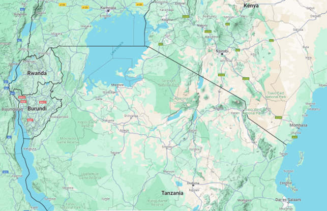
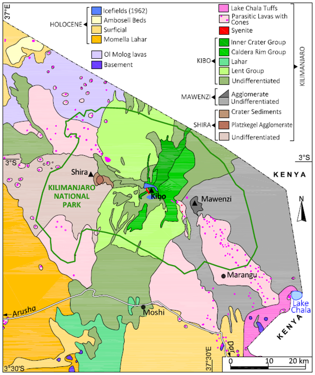
Kilimanjaro comprises three discrete volcanic centres covering an area of 80 km x 48 km and towering more than 5,000 m above the regional plateau. It is situated on the border of Tanzania and Kenya, in east Africa in an area characterised by giant free-standing volcanoes, like Mount Meru and Mount Kenya (Figure 1.1), and is about 480 km northwest of the capital, Dar es Salaam. The national park is wholly within the borders of Tanzania, and is accessed by road, or by air through the international airport at the nearby town of Arusha.
This hiker’s guide to some geological features of Kilimanjaro is designed to assist hikers in understanding some of the volcanic and sedimentary rocks traversed, and although it focuses on the Lemosho route, it also includes some broader descriptions of the rocks on the mountain. The photographs and observations were made by the author on an ascent at the end of September 2023.
Throughout this note, the author has drawn liberally from the observations made in the book: “The Geology of Kilimanjaro” describing the first geological expeditions, in 1953 and 1957, authored by C Downie and P Wilkinson of the University of Sheffield, and published in 1972.
Kilimanjaro has always captured our imagination. In about 150 AD Ptolemy of Alexandria, known as the founder of modern cartography, wrote of “a great snow mountain lying inland from Rhaphta” where Rhaphta was considered to be south of the end of the World inhabited by “man-eating barbarians”. The mountain was surely Kilimanjaro. Early records spoke of a “silver-covered mountain protected by djinns” (evil spirits) and later it was speculated that this mountain was the source of the Nile. The djinns were thought to be responsible for sickness and death on the mountain, and the locals therefore avoided climbing it (Reader, 1982).
The mountain was positively identified by European explorers for the first time by Johann Rebman, a Swiss missionary with the London-based Church Missionary Society, who on 11th May 1848 wrote on seeing the mountain for the first time: “At about 10 o’clock I observed something remarkably white on the top of a high mountain and first supposed it was a very white cloud … the most delightful recognition took place in my mind of an old well-known European guest called Snow.” This account was not universally accepted at the time, particularly by the Royal Geographical Society, and it was not until Baron von der Decken, a German explorer, and Richard Thornton, a young geologist who had previously been with Dr David Livingstone’s expedition further south, that the matter was settled.
On the 14th July 1861 Thornton wrote in his diary that the mountain: “shone out beautifully for a few minutes showing streaks of snow running down its sides at the bottom of numerous ravines to nearly the base of the upper cone”. The two explorers spent 19 days around the mountain, and climbed to 2,500 m. Sir Roderick Murchison, President of the Royal Geographical Society, conceded that Rebman had been right all along.
Many details of the physiography, the geology, the geography, the anthropology, and the botany of the mountain were recorded in Thornton’s voluminous diaries at the time.
During the mid to late 19th Century, European missionaries and explorers made a number of attempts to climb the mountain. A young Methodist missionary, Charles New, managed to ascend the mountain to about 4,000 m in August 1871. As reported to the Royal Geographical Society, New’s ascent marked the first time that a European explorer had reached the snowline.
For twenty years thereafter Kilimanjaro attracted very little attention, no doubt associated with the decline in East African geographic interest once the riddles of the Nile and the great lakes were solved.
In the early eighties Bismarck reversed his anti-colonial policies, and in 1884 in swift succession he annexed the Cameroons, Togo, South-West Africa and New Guinea. This led to some disquiet in East Africa who thought that they would be next. They were right. In early 1884 Dr Carl Peters founded the Gesellschaft fur Deutsche Kolonisation (GDK) and in December 1884 he signed treaties with 12 East African chieftains, on the basis of which in March 1885 Kaiser Wilhelm signed a Charter of Protection, effectively establishing a German Protectorate in East Africa. The land around Kilimanjaro, inhabited by the Chagga people, was initially excluded from this Protectorate, and they swore allegiance to the Sultan of Zanzibar, who had protested strongly against the annexation of his mainland territories. This turned out to be in vain, and the Chagga territories were also annexed.
In 1887, the German geology professor Hans Meyer reached the lower edge of the ice cap on Kibo, where he was forced to turn back because he lacked the equipment needed to progress across the ice. The following year, Meyer planned another attempt with Oscar Baumann, a cartographer, but the mission was aborted after the pair were held hostage and ransomed during the Abushiri Revolt. In the autumn of 1888, the American naturalist Abbott and the German explorer Otto Ehrenfried Ehlers approached the summit from the northwest. While Abbott turned back earlier, Ehlers at first claimed to have reached the summit rim, but after severe criticism, withdrew his claim (Wikipedia).
In 1889, Meyer was successful on his third attempt with the Austrian mountaineer Ludwig Purtscheller, summitting the highest point on the 6 October 1889. On 18 October, they re-ascended Kibo to enter and study the crater, cresting the rim at Hans Meyer Notch. In total, Meyer and Purtscheller spent 16 days above 4,600 m.
In 1989, the organizing committee of the 100-year celebration of the first ascent decided to award posthumous certificates to the African porter-guides who had accompanied Meyer and Purtscheller. One person in pictures or documents of the 1889 expedition was thought to match a living inhabitant of Marangu, Yohani Kinyala Lauwo, who died on 10 May 1996, 107 years after the first ascent. Yohani Lauwo is credited with being a joint first-ascender of the summit (Wikipedia).
The crater was named after the first person to look into it, Pastor Richard Reusch. He was an ex-Cossack officer turned Lutheran Missionary, who climbed the mountain forty times. On his first ascent in 1926 he discovered a frozen leopard on the crater rim, which was immortalized in Hemingway’s “The Snows of Kilimanjaro”, who in 1936 wrote: “Close to the western summit there is the dried and frozen carcass of a leopard. No one has explained what the leopard was doing at that altitude”. Sightings of fumaroles and active sulphur emissions raised questions about whether the mountain was really extinct. These questions were fuelled by the active melting of the glaciers, which was also of concern due to the perceived snow melt used for irrigation in the slopes below.
These disturbing questions led to the first geological expedition to the mountain which took place in June 1953. At the invitation of the Tanganyika Geological Survey the University of Sheffield assembled a party of seven geologists, who focused on mapping the area above 12,000’ (about 4,700m), between June and September 1953.
The second expedition in 1957 comprised six members from Sheffield University and formed part of the International Geophysical Year Programme. This program focussed on mapping the glaciers and the lower slopes of the mountain below 12,000’, so that the whole mountain would be known. This survey formed the basis for a special Kilimanjaro sheet of the Tanganyika Geological Survey, published in 1965.
Both programs suffered from accessibility, drought, and bad weather.
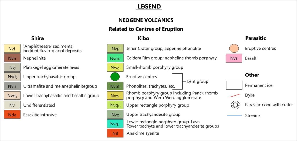
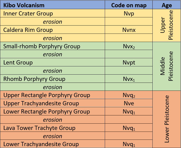
The results of these expeditions were published by the University of Sheffield in 1972 as: “The Geology of Kilimanjaro”, by C Downie and P Wilkinson. This book describes Kilimanjaro’s geomorphology, glaciology, and glacial history, as well as the geology of the three major volcanic centres of Shira, Kibo, and Mawenzi. A large amount of detailed information is given, including an account of the geological history of each centre, the nature of the major and minor intrusions, and, in some cases, flow by flow descriptions of the lava stratigraphy. The final chapter deals with the petrography and petrology of the rocks. The rock classification is based on the normative compositions of the rocks, and this classification has been followed in this description.
In his book review in the journal Nature in 1973, N Guest noted that “The text, with few significant errors, is very readable. Some splendid photographs are included – unfortunately none in colour – along with abundant, useful illustrations. A set of photomicrographs and a coloured geological map at 1/125,000, with Kibo details at 1/50,000, make the complete volume exceedingly good value for £6.”
The Kilimanjaro massif is situated at 3005’ south 37020’ east within the approximately 1,700 square kilometre Kilimanjaro National Park, entirely within Tanzania, and borders Kenya to the northeast. The mountain rises from the surrounding plain at an elevation of about 1,600 m to the Kibo peak at 5,895 m, and is ringed by towns and agricultural activity on the warm tropical plains which extend up to the borders of the park. Temperatures average about 300 on these plains and drop to below freezing on the upper reaches of the mountain. Rainwater runoff from the equatorial forest zone provides water for the numerous streams and rivers which sustain the agricultural activity on the outskirts of the park.
Kilimanjaro comprises three east-west aligned main volcanic centres: Mawenzi (5,149 m) and Kibo (5,895 m) form prominent peaks, while Shira (4,006 m) forms a broad plateau to the west of Kibo. Mawenzi is 12.2 km east of Kibo, and Shira is 14.2 km west of Kibo. Shira (2.5-1.9 Ma) is part of the older (Pliocene-Upper Pleistocene) volcanism. Mawenzi (1.0-0.45 Ma) and Kibo (0.48-0.15 Ma) are part of the younger volcanism of this area. Uhuru Peak at 5,895 m is the highest point and it is situated on the crater’s southern rim. Volcanic rocks erupted from these centres cover an area of about 6,000 km2 (Scoon, 2016), and extend well beyond the borders of the National Park.
A total volume of 4,790 km3 was erupted including 500 km3 from each of Shira and Mawenzi and 3,790km3 from Kibo. The dominant flow directions for the three centres are southwest (Shira), east (Mawenzi) and north, south and west (Kibo) (Scoon, 2016).
As Kibo was the latest volcanic vent, it only conforms to a typical shape above about 5,100 m. Below this elevation its lavas were dammed up and diverted by the pre-existing Shira and Mawenzi cones. Erosion of all three cones is greater on the southern side, attributed to greater rainfall and runoff. Above about 4,700 m the Kibo slopes and streams are dry, with the exception of glacial runoff to the south and southwest.
Water drainage is radially away from these peaks. The Shira Plateau drains to the west, southwest and northwest, with the westerly flowing Engare Nairobi river bisecting the plateau and forming the watershed. A number of southerly and south-easterly draining ephemeral, glacially charged rivers, dissect the landscape. Prominent among these are the Kikafu, Bastion, Umbwe and Karanga rivers.
Erosion has given Kibo a concave shape, with the overall higher rainfall on the southern slopes of all three peaks resulting in a more dissected landscape than the northern slopes.
Shira forms an upland plateau at about 4,000 m, and is bound to the west by a continuous wall known as the Shira Ridge, and to the south by a similar although more broken up ridge. The most prominent feature of the plateau is the Platzkegel, a horseshoe shaped peak situated on the southern ridge.
The east African climate is dominated by two seasonal winds. The south-east moisture carrying trade wind brings the long rains in March to May, and the north-east trade wind brings the short rains from November to February. A cold dry season follows the long rains, and a warm dry season follows the short rains. Most rain falls between 1,000 m and 3,000 m elevation, and preferentially falls on the southern slopes, with the northern lee slopes being relatively drier.
A Kilimanjaro ascent will typically progress through five climatic zones from agricultural land at less than 1,800m (adjoining the park gates) through rain forest, at between 1,800 m and 2,700 m, a heather-moorland zone, at 2,700 m to 4,200 m, to an alpine desert zone at 4,200 m to 5,000 m, and finally an arctic summit zone. Kibo is permanently covered in glaciers, which have progressively melted over the past 200 years or more.
Average rainfall increases from about 500 mm in the agricultural zone, to 1,800 mm in the rain forest, to 1,600 mm in the heather-moorland area. The alpine desert zone receives about 250 mm of rainfall a year, and the peak receives an estimated 125 mm per year (Reader, 1982). The vegetation and wildlife reflect this rainfall distribution, with lush vegetation in the rain forest giving way to sparser vegetation upwards, and finally disappearing above about 5,100 m.
Between May to October a dry north-east wind blows at altitudes above about 4,000 m. As this wind swirls around the mountain, it sucks up warmer clouds from below, resulting in much of the snowfall falling on the peak being from this moisture. If this wind is blowing strongly, the morning cloud cover is dissipated leaving the mountain clearly exposed to trekkers hiking the southern and northern circular routes. The cloud cover will frequently reappear in the afternoon and will blanket the mountain from view.
The wetter forests are dominated by camphor, podocarpus, and fig trees, with junipers and olive trees occurring in drier sections. Vines, Old Man’s Beard, and ferns are important components (Scoon, 2016). Wildlife including a variety of monkeys and numerous birds is abundant. The forests give way quite suddenly to heath and moorland vegetation, where grasses, proteas and ericas are frequent. Higher up, the alpine zone has spectacular giant groundsels and lobelias, particularly where water is more abundant, and tufty grasses.
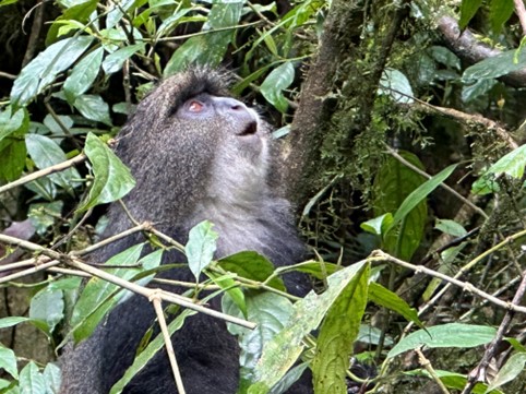
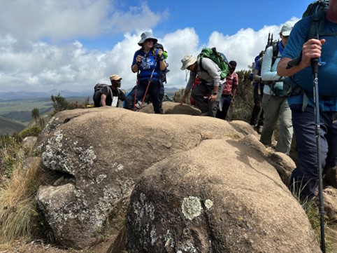
Wildlife is plentiful in the rain forest, and several species of monkey and numerous birds can be seen. A querulous blue monkey is shown in Figure 3.1.
Besides spiders and lichens, very little life survives in the summit zone.
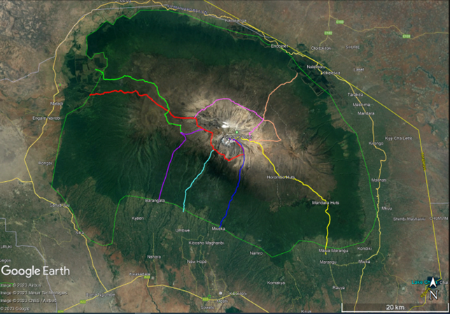
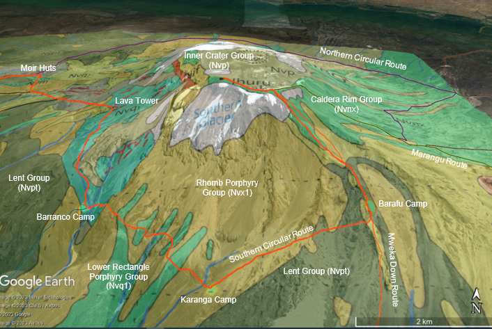
In the course of a complete climb, a hiker will use an ascent route, a summit ascent route, and a descent route, which is determined by the latter. The main physiographic features and hiking routes are shown in Figure 4.1. In this figure the Lemosho route is shown as merging into the Southern Circular route and onto the Barafu Summit route. The Mweka route is a dedicated down route. The five climatic zones are shown by distinct colour changes from green to brown to light brown on the map. The change from heather to moorland is gradual.
There are six ascent paths, as follows:
These routes were digitized in Google Earth Pro. In most cases the routes are distinctly shown on the satellite photos but become indistinct in places through the rain forest. The different climatic zones can be clearly seen in Figure 4.1.
There is a dirt road which traverses the Shira Plateau and is used for access and for medical evacuations. Helipads are located at Barranco and Barafu camps.
The total distance covered from the Lemosho gate to the summit is 44 km, and the down route from Uhuru to Mweka gate is 20.4 km.
At about 4,000 m elevation these routes all merge with a circular trail that runs around Kibo cone called either the southern or northern circular path. From these circular paths there are three summit ascent routes: The Normal or Marangu route which reaches the crater rim at Gillman’s Point (Rongai or Marangu Route), the Barafu ascent route which reaches the crater rim at Stella Point and the Western Breach ascent route (any other route). The descent route is determined by the ascent path. If you ascended via the Rongai or Marangu route you will descend via the Marangu route. From all other routes you will descend via the dedicated Mweka descent route.
About 35,000 people attempt to summit Kilimanjaro every year (although reliable statistics are hard to find). However, only two-thirds are successful mainly due to altitude sickness and other health problems that cause climbers to turn around. This fluctuates according to season. At the porter rate of ~4:1 this means that over 5,000 people start daily. The overall success rate increases with the amount of time spent on the climb, with the Lemosho 8 day and Northern 9 day routes having the highest success rates.
Our group of 12 hiked the 8 day Lemosho route in September 2023 as the slightly longer route would give a better chance of success, and also gave time to explore the volcanic rocks along the way. The Lemosho Route arguably gives the hiker the most complete view of the Shira and Kibo volcanic rocks of any of the routes. The route also included a full day on the Shira Plateau and an overnight stay at the relatively remote Moir Hut, with shorter day hikes between the final three overnight camps: Barranco, Karanga and Barafu.
We reached the summit on a full moon on 1 October 2023. This report is a description of the geology of the mountain and some personal geological observations made during the trek.
The Lemosho route follows a walk high – sleep low approach, which is thought to be best for acclimatisation. The route from Lemosho Gate (2,100 m) to Uhuru Peak (5,895) climbs about 3,800 m over 44 km. The vertical profile is shown in Figure 5.1. The down route is not shown.
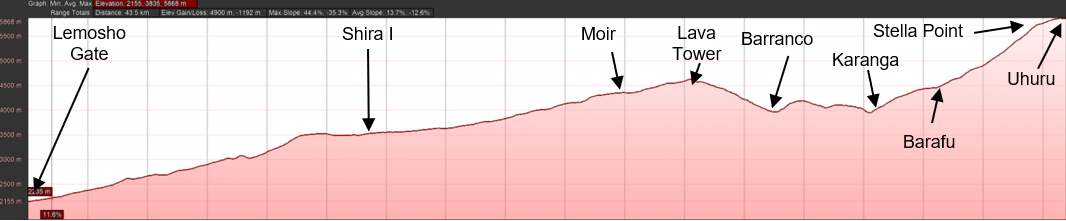
The steepest part of the ascent is from Barafu camp to Stella Point, at about 1,150 m vertical climb over 3.5 km at 28 %, or 160. The path from Stella Point to Uhuru Peak is 160 m vertical climb over 1.1 km at 15 % (8.50), but it feels much steeper.
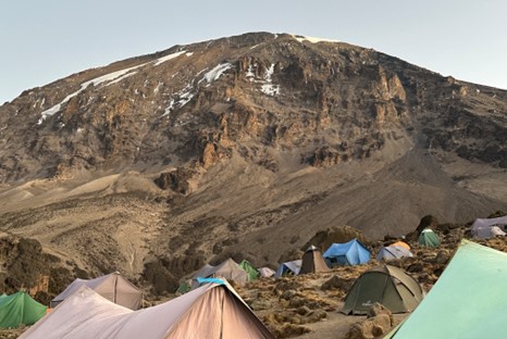
The camp and major point elevations are: Lemosho Gate – 2,100 m, Big Tree Camp – 2,650 m, Shira I Camp – 3.610 m, Moir Huts – 4,220 m, Lava Tower – 4,600 m, Barranco Camp – 3,900 m, Karanga Camp – 3,995 m, Barafu Camp – 4,673 m, and Uhuru Peak – 5,895 m.
Kilimanjaro is the largest of about 20 volcanoes located near the eastern flank of the southern end of the East African Rift Valley (EAR). The EAR is part of a ‘Y’ shaped active continental rift system where the continental lithosphere is being stretched and thinned to form two new plates; the Nubian and the Somalian plate (Scoon, 2016).
The rifting on the EAR began in the Miocene around 22-25 million years ago and continues today. It is thought that as the Nubian and Somalian plates continue to drift further away from each other, the lithosphere between them will grow thinner and drop below sea level. New oceanic lithosphere may form along the centre of the rift, producing a narrow ocean basin with its own mid ocean ridge.
According to Scoon (2016), the EAR began to assume its present shape about 2 Ma ago. The Ol Molog, Kibongoto and Kilema volcanoes were the first to emerge above the surrounding Precambrian quartzo feldspathic, hornblende and biotite gneisses and granulites, all situated within 30 km west of Kilimanjaro. They are thought to be fault controlled and are dominantly olivine basalts with little variation. These volcanoes built up a complex of peaks and valleys trending WNW-ESE and about 100 km long, sixty-five km wide, and up to 3,000 m high (Reader, 1982). Some of their lavas are overlain by Kilimanjaro lavas.
The geology in the immediate vicinity of Kilimanjaro is shown in Figure 6.1. The park itself is dominated by volcanic rocks from the three main volcanic vents: Shira, Mawenzi and Kibo. The western part is underlain by Shira lavas, by parasitic lavas with volcanic cones, and in the northwest by Ol Molog lavas. The Shira plateau averages about 3,500 m and slopes gently to the west, terminating at the Shira Ridge. The central part of the park is underlain by Kibo volcanics, while the eastern part is underlain by Mawenzi undifferentiated lavas and agglomerates, and by parasitic lavas with volcanic cones. The southern boundary of the mountain is deeply incised, particularly at the Kibo Barranco.
Between about 1 Ma and 750,000 years ago, the Shira, Mawenzi and Kibo cones began to take shape. The earliest Shira and Mawenzi lavas are known to be basaltic, and the earliest Kibo lavas are presumed to be similar. Towards the end of the Pleistocene the three cones began to develop individual characteristics.
Shira produced undersaturated lavas, ankaramites and nephelinites shortly before activity ended, followed by a period of erosion. Once volcanic activity had ceased on the Shira cone it collapsed into a huge caldera which now forms the Shira Ridge (Downie and Wilkinson 1972).
From Scoon 2016. Simplified from Downie and Wilkinson (1972). The Small-rhomb Porphyry Group is included with the Lent Group. The Kilimanjaro volcanism (2.5 – 0.15 Ma) overlies the 01 Molog lavas but is younger than the Momella Lahar
Mawenzi lavas became more alkaline passing from basaltic to trachybasalt and trachyandesites. The cone reached a height of about 4,570 m before becoming extinct. Its final act was the collapse of a segment of the cone to form the Mawenzi lahar.
Kibo reached a similar height producing trachyandesitic lavas, but its activity continued much longer after Mawenzi stopped. Minor parasitic eruptions continued to take place.
The Lower Trachyandesite Group was followed by the first period of erosion and glaciation. The Lava Tower Group came next, followed by further erosion, and then the eruption of the Upper Trachyandesite Group, and the Upper Rectangle Porphyries. After another period of erosion, the Penck Rhomb Porphyry erupted, followed by further erosion and then the eruption of the dominant Main Rhomb Porphyry Group (Nvx1). Widespread glaciation preceded the eruption of the non-porphyritic Lent Group. Eruption terminated with the Caldera Rim and Inner Crater lavas.
Kibo lavas overlap the Shira lavas in a broad north-south zone, and especially north of the Engare Nairobi River and on the vent’s southern flanks. Mawenzi also formed from a single main centre, with Kibo lavas overlapping Mawenzi lavas on the northern and southern sides of the vent.
About 250 parasitic cones occur on the lower and intermediate slopes of Kilimanjaro. Dated at between 0.20 and 0.15 Ma, they may be contemporaneous with the Reusch Crater and are associated with Strombolian-type activity that formed cones of cinder and ashes 60 – 100 m in height. They reveal a broad compositional range. Lake Chala on the Kenyan border fills a crater from which an extensive calcareous tuff has been ejected. These eruptions are thought to have destroyed a settlement several hundreds of years ago, providing the most recent evidence of volcanic activity on Kilimanjaro (Scoon, 2016).
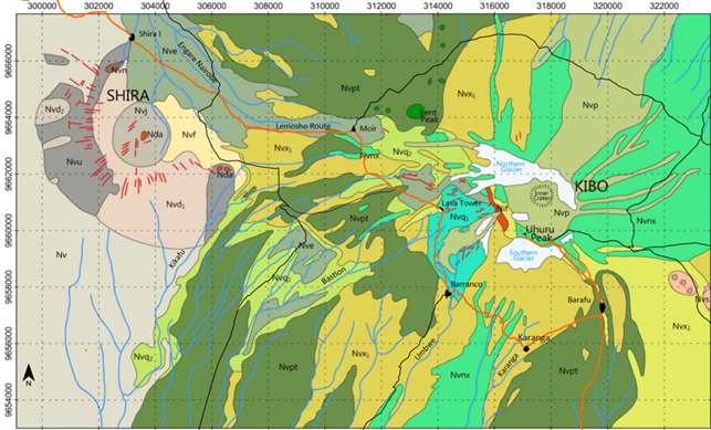
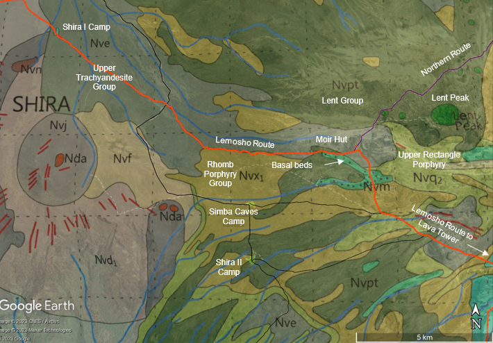
The detailed geology of the hiking route followed is shown in Figure 6.2. This map is a subset of the map produced by Downie and Wilkinson in their 1972 publication, and uses the same terminology and map abbreviations. The Lemosho route is shown in orange, and the other routes in black. The dedicated Mweka down route is also shown in orange. In Figure 6.1 the Rhomb Porphyry Group (Nvx1) and the Small Rhomb Porphyry Group (Nvx2) are included in the non-porphyritic Lent Group (Nvpt) or as undifferentiated lavas but are shown separately in Figure 6.2.
The overnight camps used on this particular ascent are shown on the map. The Lava Tower is also shown, but not the Western Breach ascent which extends upwards from the Lava Tower to the crater rim and onwards to Uhuru.
The Lemosho hiking route traverses undifferentiated Shira volcanics to just east of the Shira Ridge, and onto the Upper Trachyandesite Group (Nve) of the Kibo Volcanics in the vicinity of Shira I Camp. From there the route traverses across the slightly easterly dipping Shira plateau, until encountering phonolites of the Lent Group. Rocks and boulders of this group of lavas are scattered across the landscape. After crossing the rescue road, the path follows the Lent Valley along the contact between the basalts and phonolites of the Rhomb Porphyry Group (Nvx1) and the Upper Trachyandesite Group (Nve). On the northern side of the valley, glacial moraines can be seen. Close to Moir Hut, the trail follows the contact between the Rhomb Porphyry Group and an outlier of the basal beds of the Calsera Rim Group.
A short hike to the north from Moir Hut along the Northern Route takes the hiker to close to the Lent Peak and associated lava plugs, and across the contact between the Upper Trachyandesite Group (Nve) and the lavas of the Lent Group (Nvpt). From this trail there are magnificent views of thick individual lava flows of the Upper Trachyandesite Group (Nve) and of the Upper Rectangle Porphyry Group (Nvq2), both showing pahoehoe surfaces.
From Moir Hut the route turns southwards, recrossing the phonolites and basal beds, and in succession the Rhomb Porphyry Group (Nvx1) and the Upper Rectangle Porphry Group (Nvq2), following the contact between these two rock types where the trail from Moir Hut joins the trail from Shira II Camp. The route then crosses onto the Lent Group (Nvpt), back onto the Upper Trachyandesite Group (Nve), and finally encountering the Lower Rectangle Porphyry Group (Nvq1) at Lava Tower. These are the oldest Kibo lavas encountered on the trail.
From Lava Tower the trail stays on the Lower Rectangle Porphyry Group (Nvq1) until encountering the Rhomb Porphyry Group (Nvx1) close to Barranco Camp. Spectacular lava flows of the Lower Rectangle Porphyry Group (Nvq1) are exposed on the Barranco Wall, crossing back onto Rhomb Porphyry Group (Nvx1) interfingered with sediments and lava flows of the Caldera Rim Group (Nvnx) until reaching Karanga Camp.
From Karanga the trail follows the Rhomb Porphyry Group (Nvx1) and crosses onto the Lent Group (Nvpt) close to Barafu Camp, where spectacular ersional deposits are encountered. From Barafu the trail follows the Lent Group (Nvpt) upwards, and onto the Caldera Rim Group (Nvnx) lavas until the summit.
The Lemosho Route thus crosses an almost complete succession of Shira and Kibo volcanics, although not necessarily in chronological order. The juxtaposition of certain rock types, and the lack of exposure of others, is largely due to the cycles of deposition and erosion that characterised the Kilimanjaro lavas.
Hans Meyer recognised Shira as a degraded earlier centre of volcanic activity, but few geological investigations took place until the Sheffield University expeditions. The Shira Plateau itself is a broad, westerly dipping plateau situated at between 3,500 m elevation to 4,300 m elevation. The plateau is marked on its western side by a prominent 3 km arcuate north-south ridge.
The Platzkegel is a rocky conical hill rising about 270 m above the plain situated on the southwestern edge of the plateau. A string of north-west trending parasitic cones extends along the northern edge of the plateau onto the lower Kibo slopes (Figure 6.1).
From the Lemosho gate it is about an 11.5 km hike, climbing from about 2,100 m to the top of the ridge at about 3,550 m. At times the gradient is quite steep, and the first 9 km is at a gradient of 9 %. It is 1.4 km from the top of the ridge to the Shira I camp.
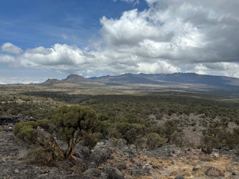
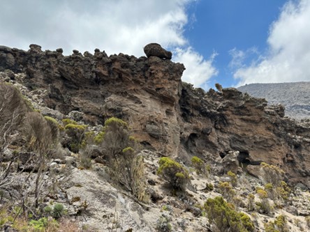
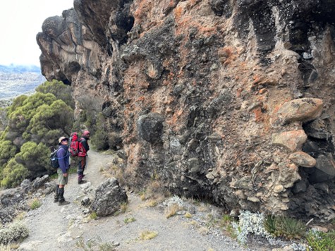
There are few rock outcrops along this part of trail although this is compensated with some excellent views of Mount Meru situated about 50 km to the south-south-east. As one ascends prominent lava flows on the upper reaches of the Shira Ridge become apparent, and the softer forest underfoot conditions give way to rocky conditions. An example is shown in Figure 7.1.
From Lemosho Gate the route traverses what are mapped as undifferentiated Shira lavas, through the rain forest to the first camp, Mti Mweka Camp. There is no outcrop along the path. On day 2 until we exited the rain forest there was also no outcrop along the path, and from there until the top of the Shira ridge there was sporadic but good outcrops of porphyritic lavas. The rhombohedral feldspar crystals were set in a fine-grained matrix, and the positive weathering of these crystals relative to the matrix provided a naturally firm, although rocky, footing.
The outcrop is present mainly as weathered and rounded in situ and loose boulders, frequently covered with light coloured lichen, as shown in Figure 7.1. Once the ridge was crossed, which we did at an altitude of 3,550 m, it was a gentle downward slope towards Shira I Camp. On this part, we crossed the mapped boundary between Shira and Kibo volcanics, although we didn’t see the exact contact due to lack of outcrop.
Kibo volcanism began in the early Pleistocene and in places the earliest lavas are indistinguishable from the Shira and Mawenzi lavas. Lavas gradually became more undersaturated culminating in the nepheline-rich Caldera Rim and Inner Crater Groups. During the lengthy periods of erosion which separated the episodic volcanism deep valleys were cut resulting in the cone not growing much from its height in the Lower Pleistocene. Not all the lava erupted from the central vent, and flank fissures, such as the Lent and Lava Tower vents, were prominent.
The volcanic sequence of the dominant Kibo volcanism is shown in Figure 8.1. The map codes in Figure 8.1 refer to Figure 6.2. Periods of volcanic eruption were followed by periods of erosion. In all 10 eruption episodes are recognised, each followed by a period of erosion (Downie & Wilkinson, 1972). The most extensive lavas, named the Rhomb Porphyry Group, erupted about 360,000 years ago, in lava flows about 15 m thick, but extending up to fifty metres thick (Reader, 1982).
The periods of glacial erosion in between the volcanism sculpted the profile that we see today. About 100,000 years ago a huge landslip breached the south crater wall and carried away about 1,000 m of the cone, thus creating the impressive Barranco valley and wall.
For detailed descriptions of the volcanic rocks the reader is referred to Downie and Wilkinson (1972).
There is little pyroclastic rock associated with any of the erupted groups. Volcanism progressively weakened with time. About 200 or more years ago a mild puff left ash around the rim of the vent, and eruption ceased. Reader (1982) estimates that Kilimanjaro volcanism piled four billion cubic metres above the surface.
From the top of the Shira Ridge to Uhuru Peak the Lemosho path traversed Kibo volcanic rocks, as shown in Figure 6.2. The sequence of Kibo volcanism is shown in Figure 8.1.
The Lemosho path crosses many of these volcanic rocks, and observations will be described in the time of formation sequence, starting with the oldest rocks.
The Bastion and Umbwe streams have created deep erosional incisions to the southwest of Kibo, exposing these oldest lavas (Figure 6.2). In the Bastion stream these lavas are exposed immediately east of the Lava Tower. The lava flows are about 4 m thick, with a layer of flow breccia at the base. The lavas are fine-grained trachyandesites with crystals of labradorite 2 to 4 mm in length.
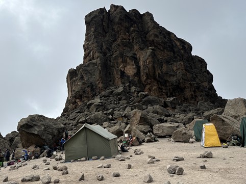
The Lava Tower Trachyte is exposed at Lava Tower itself, and towards the southwest. The lavas are green and fissile, with well-developed flow structures and a green chloritic sheen. Obsidian fragments are common.
The Lava Tower is shown in Figure 8.2. The elevation of the base of the tower is at 4,600 m, the highest point on the southern circular route until the Barafu Camp is reached. The tower has weathered into large mostly blocky and angular boulders, at the base.
This is the first group of lavas to have a demonstrably wide extent. It outcrops on the upper reaches of the peak, and extends extensively across much of the Shira Plateau, especially in the Oehler and Lent valleys. It also appears on the Machame Escarpment and as inliers in the Lent Group. According to Downie and Wilkinson the lava flows average 3 m thick, with a thin flow breccia at the base.
The Lemosho Trail between Shira I camp and Moir hut traverses the Upper Trachyandesite group (Nve) for much of this section of its length (Figure 8.3). This section of the hike is 9.2 km, and the path climbs 660 m steadily from 3,500 m at Shira I to 4,160 m at Moir hut. The Shira plain is gently sloping, and is crossed by westerly trending streams, which drain into the Engare Nairobi stream. The vegetation is moorland grasses and small bushes and trees. The path crosses the rescue road at 3.9 km, where a turn to the south will take the hiker to the Simba Caves camp and on to Shira II camp. The Upper Rectangle Porphyry group (Nvq2) is not encountered on this trail.
At 5.3 km from Shira I the path follows (for 2.6 km) the contact between the Upper Trachyandesite group (Nve) and the Rhomb Porphyry group (Nvx1) to the south. The path then encounters Lent Group phonolites, basalts and lahar’s, before passing back onto Upper Trachyandesite lavas for the last 500 m. A 140 m climb at 10 % gradient northwards from Moir hut along the northern circular route takes the hiker onto the Lent Group lavas, with excellent views of the Lent Peak and associated lava towers.
The Shira Plateau is scattered with outcrop and discrete boulders and rocks of the Upper Trachyandesite group. Some of the rounded boulders can be quite large, and along the trail measured up to 3 m x 3 m in size. The rock is porphyritic and the frequently aligned and clustered rhombohedral feldspar crystals are set in a fine-grained greyish coloured groundmass. The crystals are 3 mm to 5 mm in length, and the rock is frequently covered by greenish and dark yellowish lichen. Grasses are ubiquitous on the gently undulating plateau.
The lavas of the Upper Rectangle Porphyry Group (Nvq2) are exposed in the Lent valley to the south and southwest of Lent Peak. They form prominent 3 to 10 m thick lava flows with pronounced pahoehoe surfaces and terminations. The lavas are visible from the hike up the northern route towards Lent Peak.
The rhomb porphyries are the flows most characteristic of Kibo. East of Kibo they crossed the saddle and were diverted north and south of Mawenzi. Westwards they reached the Shira caldera floor and overlapped the Shira volcanics to the north and northwest. The lavas extend up to 40km northwards and a similar distance to the south. In the south the lava flows are confined between two upstanding arches situated to the east and west, limiting their lateral extent to about 15 km wide in the upper reaches of the mountain.
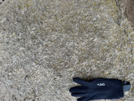
The rhomb porphyries are remarkably uniform massive lavas. The matrix is dark grey and fine-grained. The phenocrysts are typically 30 to 40mm in length and constitute 30 to 60 % of the rock. Lava flows are typically 8 to 30m thick, with pahoehoe surfaces. The rocks are dark coloured, occasionally vesicular lava with rhombohedral feldspar crystals between 2 mm and 5 mm long forming between 30 % and 60 % of the rock mass. The crystals are frequently sub-horizontally aligned.
The Rhomb Porphyry on the upper mountain slopes is shown in Figure 8.5. The Rhomb Porphyry extends from the ridge on the right, to the ridge at the top, and to the Big Breach glacier situated to the left of the photo. The colour and slope angle change (arrowed) marks the change from the Rhomb Porphyry to the Caldera Rim Group, as mapped by Downie and Wilkinson (1972).
The porphyry is covered by moraine scree at the concave nick point half way down. Rivulet incisions in the moraines attest to previous and ephemeral water flows from glacial melt.
Horizontal lava flow layering is apparent in the immediate face, with slightly southeasterly dipping lava flow layering apparent on the right hand side of the photograph. The rock faces is incised with narrow, erosion cracks. The rocky Karanga Camp, from which the photo is taken, is on Rhomb Porphyry rocks, and good exposures can be examined.
Uhuru Peak is obscured from this angle, although the approximate position is marked.
Barranco Camp is also situated on the Rhomb Porphyry Group. Figure 8.6 shows aligned rhombohedral feldspar crystals in an outcrop of rhomb porphyry, taken at Barranco camp.
Before the Lent Group there was a period of erosion during which the rhomb porphyries were eroded and considerable sediment deposits accumulated. Erosion removed the rhomb porphyries from the lower Lent Valley, in some valleys to the north, and in some areas around the Oehler Valley and the Barranco at higher altitudes. In these places the Lent Group rests directly on rectangle porphyries and trachyandesites.
This erosion was partly glacial and Downie and Wilkinson (1972) note glacial and tillite beds beneath the Lent trachytes at a number of localities. These were recorded on the Machame escarpment, at the Galuma Caves, and at the Karanga outwash. The latter deposits can be viewed on the valley immediately to the west of Barafu Camp, where great thicknesses of sand and boulder sediment fill U-shaped depressions in the rhomb porphyry. Here the boulders, largely comprising rhomb porphyry rocks, reach diameters of 3 m across, although the sediment is largely composed of bedded sand and gravel (Figure 8.7). Along the path large boulders of lava can be seen delicately balanced on weathered arenaceous sediments.
Although the sedimentary rocks are prominently displayed along the hike, they have not been included in Downie and Wilkinson’s 1972 map of Kilimanjaro. This is particularly apparent in the sedimentary sequence in the valley immediately to the west of Barafu Camp.
The Lent Group consists of a widespread group of trachytes and phonolites, spread over northern, northwestern and southern flanks, and emanating from four main vents.
An almost unbroken field of phonolite covers the north west flanks of Kibo covering a triangular area of about 310 km2 (see Figure 6.1 and Figure 6.2). The field widens downwards and below the forest it extends northwards and to the northwest. It reaches a distance of about 32 km from the Lent Peak. Several outliers of rhomb porphyry are exposed in river valleys. Glacial erosion in the Lent Valley has isolated an outcrop of Lent Group lavas along the southern side of the valley. The Lemosho trail traverses this outcrop within a km of Moir Huts. The field is obscured in places by cinder cones and parasitic Shira lavas. The lavas are remarkably uniform and reach a thickness of about 330 m.
On the southwest slopes of Kibo the Lent Group can be traced from the lower Barranco across the Bastion Stream to beyond the Oehler Valley. The exposures are limited by an almost continuous cover of glacial deposits (Figure 6.2 and Figure 8.3). These lavas extend down into the forest zone, and are last seen near Machame.
On the south-east slopes of Kibo, the Lent group is apparent immediately east of the Karanga Camp, and is traversed on the steep path leading up to the camp, which is itself situated on the Lent Group lavas (Figure 8.4). Upslope the lavas disappear under the Rhomb Porphyries and under the Caldera Rim Group. The lateral extent of the lavas increases downslope, and becomes dissected by valleys where underlying rocks are exposed. The Lent Group extends to just beyond the southern boundary of the park, where it merges with the flows down the southwestern slopes, to form an almost continuous lateral strike of 18 km.
The Machame Route ascent is almost entirely on Lent Group lavas, as is the Umbwe Route, until these reach the southern circular path.
On the northeast slopes of Kibo phonolites of the Lent Group appear below the Crater Rim Group. The distribution appears to be limited, but isolated flows can be seen along the Rongai Route.
The Lent Group lavas are similar wherever they occur, consisting of fine-grained phonolites and phonolites with occasional sparse small feldspar phenocrysts. The flows are invariably accompanied by quantities of obsidian occurring at the sides or base of flows. The flows vary from 3 to 10 m thick and flow structure is strongly marked.
The flows appear to have occupied shallow valleys and show a pattern of narrow meandering lava fingers. On occasions the flows occupy deeper valleys and these exhibit tunnel collapse structures.
The four phonolite fields appear to have different sources, with the northwest and south-west fields being from flank fissures. The north-east and south-east lavas are probably also from flank fissures, but Downie and Wilkinson (1972) do not rule out Kibo as an additional source for these lavas.
The Caldera Rim Group consists mainly of flows of rhomb porphyry with visible nepheline phenocrysts. It is of recent formation and the flows retain their original form. They are well exposed in the cliffs of the present caldera. Gillman’s Point, Stella Point and Uhuru Peak itself are located on these lavas. The caldera is rimmed by these lavas, and individual flows can be traced to the east, north and north-west. On the north-east they completely cover the underlying rocks (Figure 6.2). The Caldera Rim group can be subdivided into three distinct units as follows:
Close to Moir huts the path follows the base of a debris flow, mapped as Caldera Rim group rocks by Downie and Wilkinson (1972). According to Scoon (pers com, 2023) this rock appears to be a debris avalanche deposit (DAD). In this deposit, which is roughly 6 to 10 m thick along the outcrop that we traversed, rounded to sub-rounded to angular lava boulders and lighter-coloured angular fragments are jumbled together in a matrix consisting of fragments of a variety of sizes and compositions. The deposit is shown in Figure 8.8. It is underlain by the lighter coloured phonolites mentioned earlier and is overlain by a 5 to 8 m thick massive lave flow.
These beds are mapped as basal beds of the Caldera Rim Group.
Subsequent to the eruption of the small-rhomb porphyries, which overlie the Lent Group, a period of erosion followed which reached depths of up to 30 m. Ice is thought to be the main erosion agent.
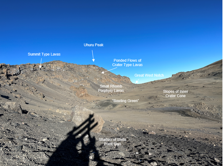
The nepheline rhomb lavas ring the caldera on the southern side but are obscured by ice on the northern rim. On the southern rim the scarp follows the caldera rim fault in a slightly northeastern direction resulting in the lava sequence being exposed looking northwards. The sequence of Caldera Rim and Inner Crater lavas is shown in Figure 8.9. This photo is taken from Stella Point (the shadow of the sign is shown in the immediate foreground) looking towards Uhuru Peak. The crater itself is to the right of the photo.
The scarp shows summit type lavas gently dipping to the southeast, underlain by Camp and Crater lavas, and by small rhomb porphyry beds. The Great West erosional notch is shown in the background, with the Inner Crater lavas overlapping in the centre of the photo. The “bowling green” is shown in diagrams in Downie and Wilkinson (1972) although no explanation is given.
In this photo the Inner Crater lavas dip outward at 100 towards the south.
The underlying small-rhomb porphyry group forms the base of the scarp but it is largely obscured by talus. It forms the rim and floor of the basin in which the flat lying Inner Crater lavas accumulated.
The rocky promontories of Stella Point and Gillmans Point are formed by massive flows of summit lavas. The cliff beneath is formed from camp lavas. These tend to fill valley floors and dip outwards at 300. No remnants of the Caldera Rim group are preserved in the 200 m wide Great West Notch. To the north of this gap the Caldera Rim lavas can be found on the outer rim, where they pass under ice further north.
On the western slopes of Kibo the lavas can be traced for considerable distances, where they tend to be of summit type.
Boulder beds, tuffs and agglomerates of the basal beds have been identified in the Lent Valley.
Several large flows of nepheline rhomb porphyry have been mapped on the southern slopes of Kibo, but no basal beds. The east slopes of Kibo are largely covered by nepheline rhomb porphyry extending onto the saddle. They increase in number towards the northeast corner where they completely obscure the underlying lavas.
The last volcanic episode formed the Inner Crater Group, by which time the Kibo had reached its present topographic form. Where the Inner Crater lavas spilled over the rim flanks they followed pre-existing valleys, scoured by glaciation.
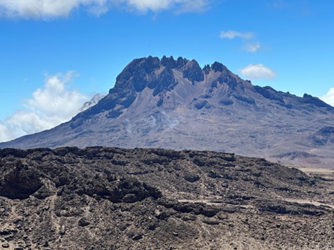
Mawenzi has been recognised as Kibo’s twin though it is much smaller and if first ascended by Fritz Klute in 1908. At 5,149 m it ranks as the third highest peak in Africa. It is deeply eroded with a treacherous and jagged summit crest, and deeply eroded steep slopes. Downie and Wilkinson (1972) believe that the end of Mawenzi volcanism was penecontemporaneous with the early stages of Kibo volcanism, particularly with the Lava Tower trachyte. The later Kibo lavas overlie Mawenzi, particularly in the Saddle area between the two peaks.
The lavas are not characterised by large lava type units, although the lavas gradually change from basalts to trachyandesites. Because of this, and the intermingling of lavas from Kibo, Mawenzi and the many parasitic eruptive centres (Figure 6.1) it was not possible to separate the lavas. However, two main groups have been recognized: the older Neumann Tower Group is basaltic, non-porphyritic, feldsparmicrophyric or with augite and olivine phenocrysts. The upper Mawenzi Group lavas are younger and overlap in time with the later flows of the Neumann group. They are trachybasalts and trachyandesites with large tabular feldspar crystals.
Barafu camp provides magnificent views of the Mawenzi peak, as shown in Figure 9.1.
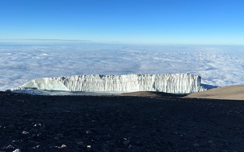
In Figure 8.4 the extent of the southern glacier is shown as mapped by Downie and Wilkinson in the 1950’s. The current extent of glaciation can be seen in the 2023 Google Earth underlay. Areal digitising shows that 73 % of the areal extent has disappeared in the intervening 70 years. At this rate the southern glacier could disappear in about 20 to 25 years time, or before 2050.
Whilst this will immeasurably detract from the ascetic appearance of the mountain, the loss of the limited amount of snow melt which contributes to lower mountain agricultural activities may have an impact on these activities. Of greater impact may be that hikers will no longer have access to water in the upper reaches of the mountain.
The upper edge of the remains of the southern glacier is shown in Figure 10.1.
The United Nations has identified about 18,600 glaciers across 50 UN World Heritage sites. They represent almost 10% of the Earth’s glacierised area and include renowned tourist spots and places sacred to local populations. In a recent report, they use satellite data to show glacial retreat. Their conclusion is that Glaciers in a third of UN World Heritage sites will melt within three decades, a UNESCO report found.
According to the UN Mount Kilimanjaro’s last glaciers may vanish by 2050.
This study would indicate that the melting of Kilimanjaro’s glaciers is not a local phenomenon but is part of a broader change in the climate.
Downie, C and Wilkinson, P (1972). The Geology of Kilimanjaro. Prepared by the Geology Department University of Sheffield, and the Geological Survey of Tanzania. 253pp
Guest, N J (1973). Nature Vol. 245 October 26 1973 Book review supplement – The Geology of Kilimanjaro
Reader, J (1982). Kilimanjaro. Published by Universe Books. 84pp
Scoon, R N (March 2016). Africa’s Highest Peaks. Published in Geobulletin: A publication of the Geological Society of South Africa
https://www.usgs.gov/media/images/mount-kilimanjaro-tanzania
https://www.bbc.co.uk/news/science-environment-63489041
Thank you to tour operator Follow Alice, their organisers, guides and porters, who helped us to successfully and safely summit the mountain.
Creo Design created Figure 6.2 based on Downie and Wilkinson’s (1972) map, which is used as overlays in Google Earth in Figure 8.3 and Figure 8.4.
For further information please contact Matt at matt.mullins@snowdenoptiro.com.
